![]()
Ex-Cyclone Hale: N. Auckland Gets Month's Rain in 24s; Gisborne Residents Told to be Ready to Evacuate
January 10, 2023
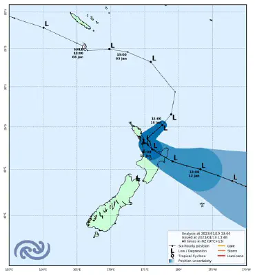
PHOTO: Met Service
This week’s former tropical cyclone that has brought misery to Coromandel Peninsula just days after an earlier storm saw roads awash and holidays ruined is set to become a “one-in-20-year event”.
Thames Coromandel District Council said fresh off a briefing with MetService and Waikato Regional Council, its emergency management team had been advised that 400mm of rain was now forecast to fall for the event through to 10pm, meaning ex-Cyclone Hale would likely be a one-in-20-year storm event.
”While the cyclone is set to begin easing off tonight and through tomorrow, our catchments are struggling to cope so expect widespread surface flooding, slips, storm surge, and road closures to continue,” said the council this afternoon.
More than 500 households in total are affected. Powerco were working to restore connections.
”We have another six to eight hours of this cyclone at its current intensity, so the message to everyone is stay off the roads and beaches for your own safety – it’s dangerous,” said Civil Defence Controller Garry Towler.
The latest track map is very similar to the previous with Cyclone Hale expected to track towards Great Barrier Island today, then change direction and move towards the southeast tomorrow https://t.co/7wKJumOqMX ^PL pic.twitter.com/2mpb6jSlUi
— MetService (@MetService) January 10, 2023
Here's an analysis of the situation at Noon that was drawn by one of our meteorologists. Note Cyclone Hale has made an appearance in the top right corner https://t.co/Yjbq0jgaoz ^PL pic.twitter.com/0P48z9nfFF
— MetService (@MetService) January 10, 2023